
At around 3:49 p.m. on April 1, 2025, an earthquake with a magnitude of 6.0 struck off the coast of Ogi, Sado City, Niigata Prefecture. Following the quake, tsunami waves were observed along the Hokuriku coastline. In Wajima City, a tsunami of 1.2 meters was recorded, while Toyama City saw waves of 80 centimeters and Kashiwazaki City 40 centimeters, causing widespread alarm.

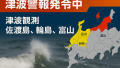
Japan Meteorological Agency Issues Tsunami Warning: “Absolutely Do Not Approach the Coast”
Immediately after the earthquake, the Japan Meteorological Agency announced the possibility of a tsunami in the central Sea of Japan and issued tsunami warnings for the coastal areas of Noto in Ishikawa Prefecture, Sado in Niigata Prefecture, and Toyama Prefecture. Residents along the coast were repeatedly urged to evacuate to higher ground or other safe locations away from the shore without delay.
Since subsequent tsunami waves can be higher than the first, do not approach the sea until the warning is lifted.
No Casualties Confirmed, But Remain Vigilant
While there have been reports of damage to port facilities, no human casualties have been confirmed so far. However, natural disasters often strike without warning and can recur. Even a moderate earthquake like this one can pose a significant tsunami risk, reminding us of the importance of preparedness.
Tsunamis Arrive “After the Earthquake”
Although the Sea of Japan side is often considered to have a lower tsunami risk, over 100 people lost their lives to the tsunami following the 1983 Sea of Japan Earthquake. Because tsunamis often arrive tens of minutes after the initial quake, the basic rule is to evacuate immediately if you feel shaking.
Are You Prepared to Evacuate?
Disasters can strike at any time. Please check the following regularly:
- Do you know the evacuation routes from your home, workplace, or school?
- Is your emergency grab bag stocked with necessary supplies?
- Have you shared contact methods with your family?
- Have you checked the local hazard map?
Rely on Official Information
During disasters, do not be misled by unverified information on social media. Always act based on information from the following official sources:
- Japan Meteorological Agency tsunami information
- Disaster prevention emails and apps from local governments (registration recommended)
- Public media such as TV and radio
Visualizing Risk with Tsunami Hazard Maps
The following websites allow you to visually check whether your area is at risk of tsunami impact:
- Geospatial Information Authority of Japan Hazard Map Portal
- Cabinet Office Disaster Prevention Information Page
Viewing these maps makes it clear that even a one-meter tsunami has the power to take lives.
A Message from “Tsunami Safe”
Please use this tsunami as a lesson and discuss emergency actions with your family and community. Protecting your life depends on daily preparedness and a split-second decision.

コメント